


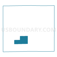
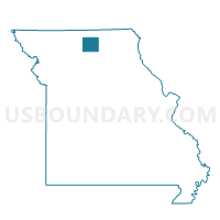
Reger Voting District, Sullivan County, Missouri
About
Outline

Summary
| Unique Area Identifier | 611443 |
| Name | Reger Voting District |
| County | Sullivan County |
| State | Missouri |
| Area (square miles) | 22.23 |
| Land Area (square miles) | 22.02 |
| Water Area (square miles) | 0.21 |
| % of Land Area | 99.05 |
| % of Water Area | 0.95 |
| Latitude of the Internal Point | 40.11658400 |
| Longtitude of the Internal Point | -93.17114270 |
Maps

Graphs
Select a template below for downloading or customizing gragh for Reger Voting District, Sullivan County, Missouri


Neighbors
Neighoring Voting District (by Name) Neighboring Voting District on the Map
- Browning Voting District, Sullivan County, MO
- Humphreys Voting District, Sullivan County, MO
- Pleasant Hill Voting District, Sullivan County, MO
- South Polk Voting District, Sullivan County, MO
- Taylor Voting District, Sullivan County, MO
- West Polk Voting District, Sullivan County, MO
Top 10 Neighboring County Subdivision (by Population) Neighboring County Subdivision on the Map
- Polk township, Sullivan County, MO (2,910)
- Bowman township, Sullivan County, MO (395)
- Duncan township, Sullivan County, MO (385)
- Pleasant Hill township, Sullivan County, MO (142)
- Taylor township, Sullivan County, MO (98)
Top 10 Neighboring Unified School District (by Population) Neighboring Unified School District on the Map
- Milan C-2 School District, MO (3,958)
- Linn County R-I School District, MO (1,580)
- Grundy County R-V School District, MO (1,040)